As with most of my travels, I saw a picture of the Pisac ruins (at my B&B El Tuco) which made me want to go see them myself. Coco rated Pisac too, his advice to date had been great, quite invaluable in fact. He also recommended the market in the town square, so I added that to my to-do list for the day too. Pisac was one of my best hiking days, I finished the day off very tired and more than satisfied.
Getting to Pisac
There are a few places to get a colectivo to Pisac (spelt incorrectly in my previous posts), I chose the same place I took to get to Tambomachay, Puka Pukara and Qenqo. Except I didn’t take the bus as the colectivo is quicker. The colectivo pick-up point is over the road from the bus stop – same road though.
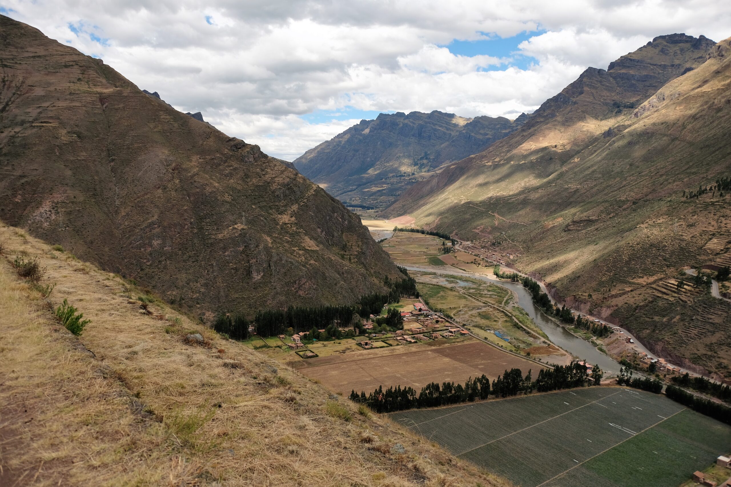
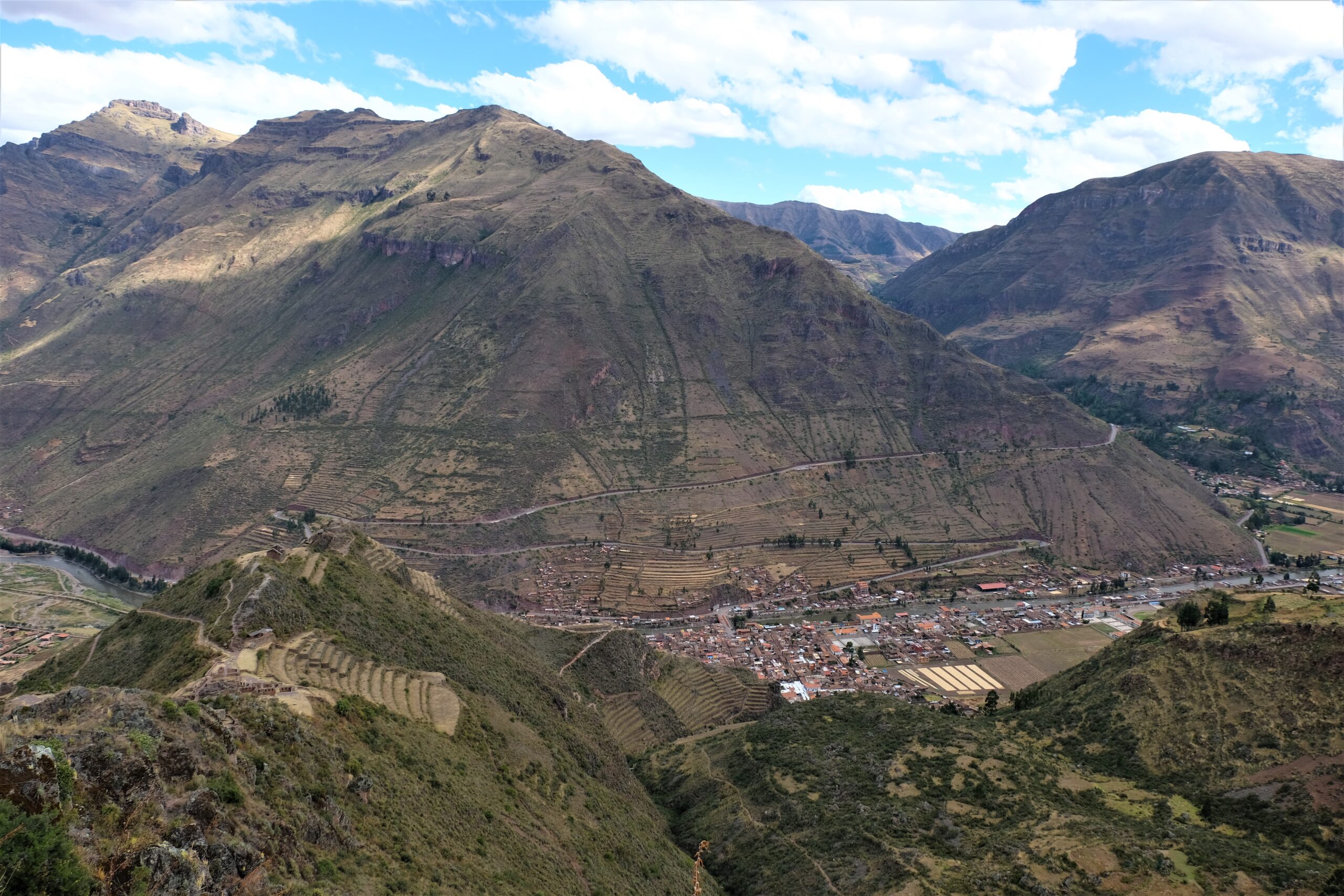
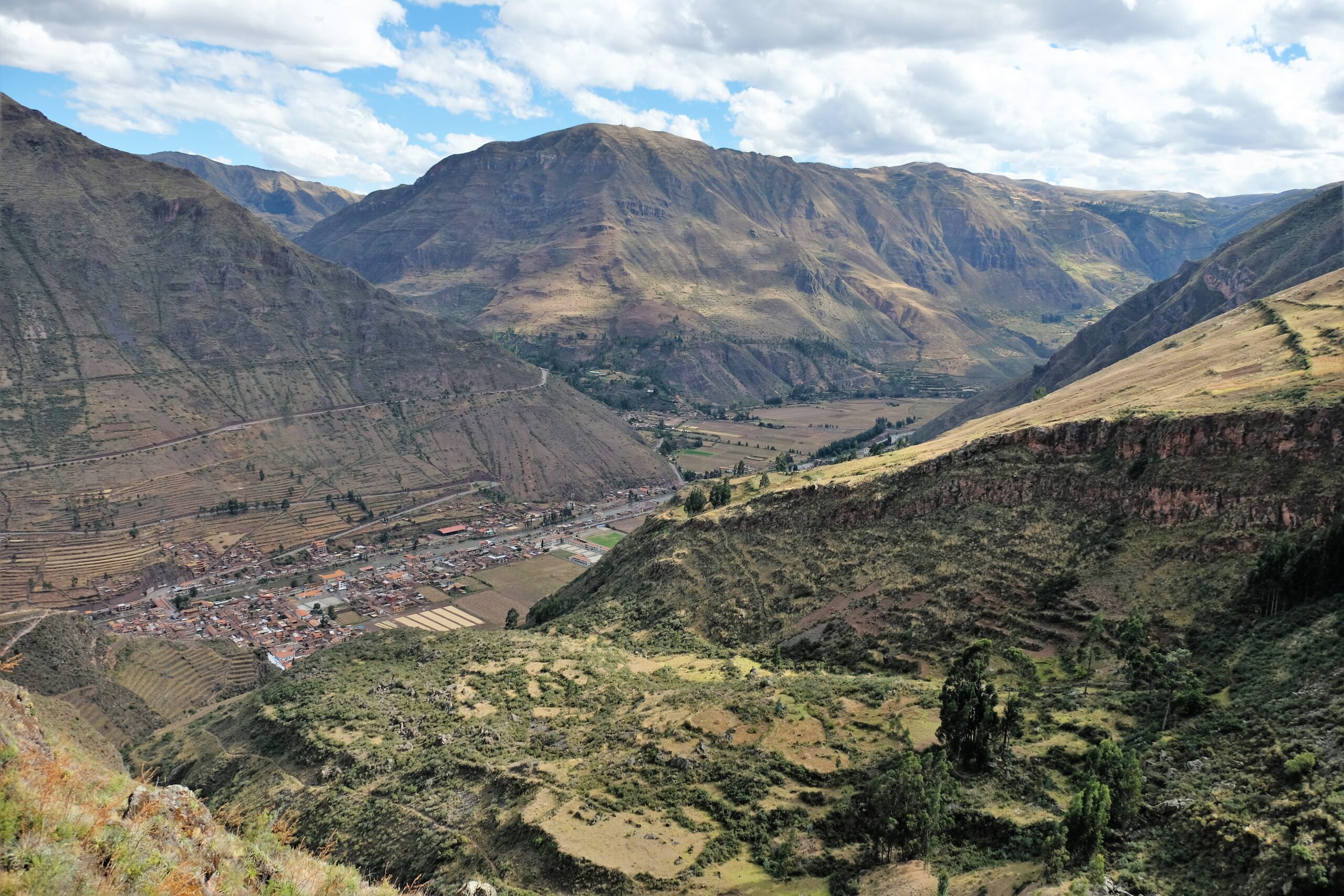
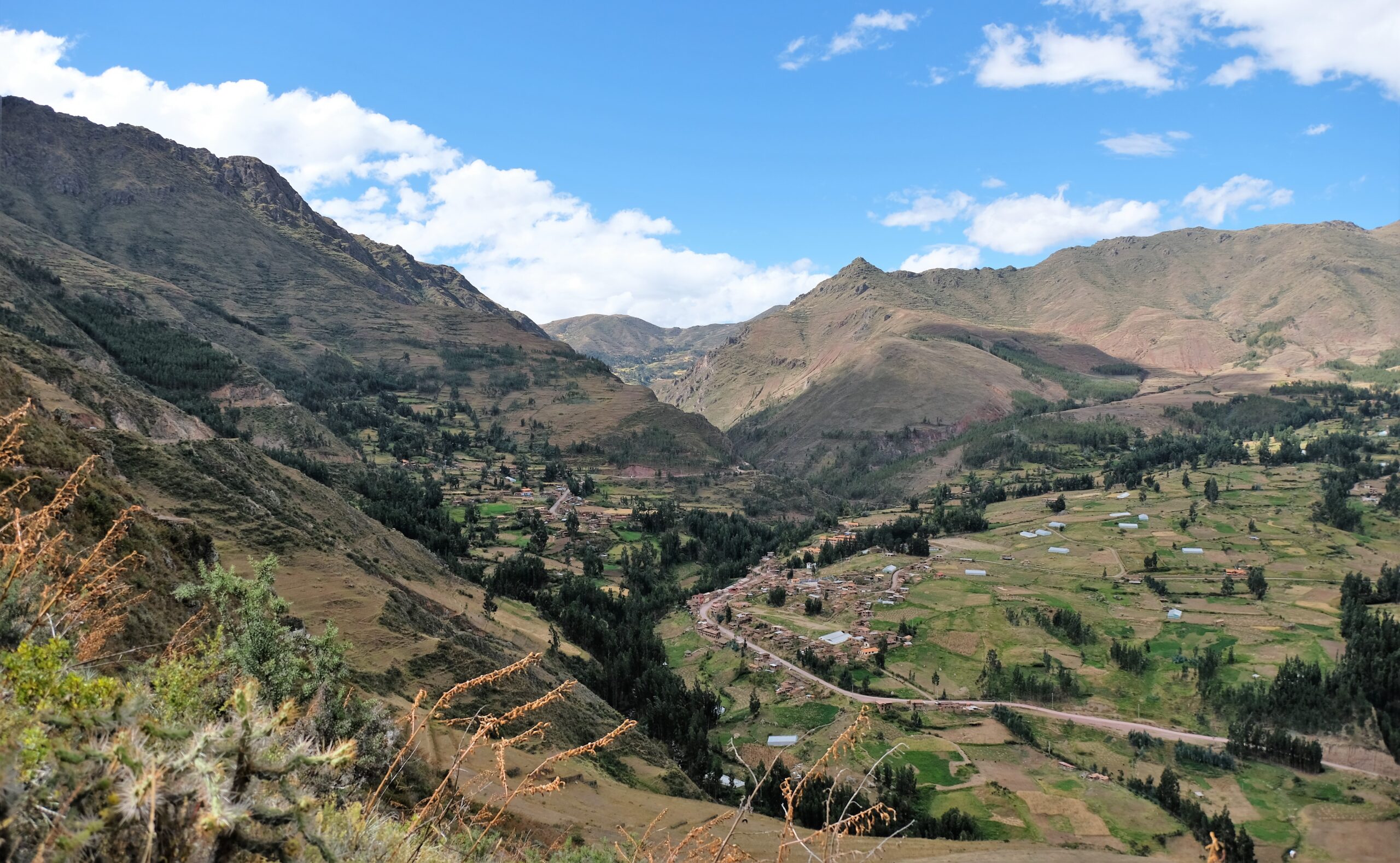
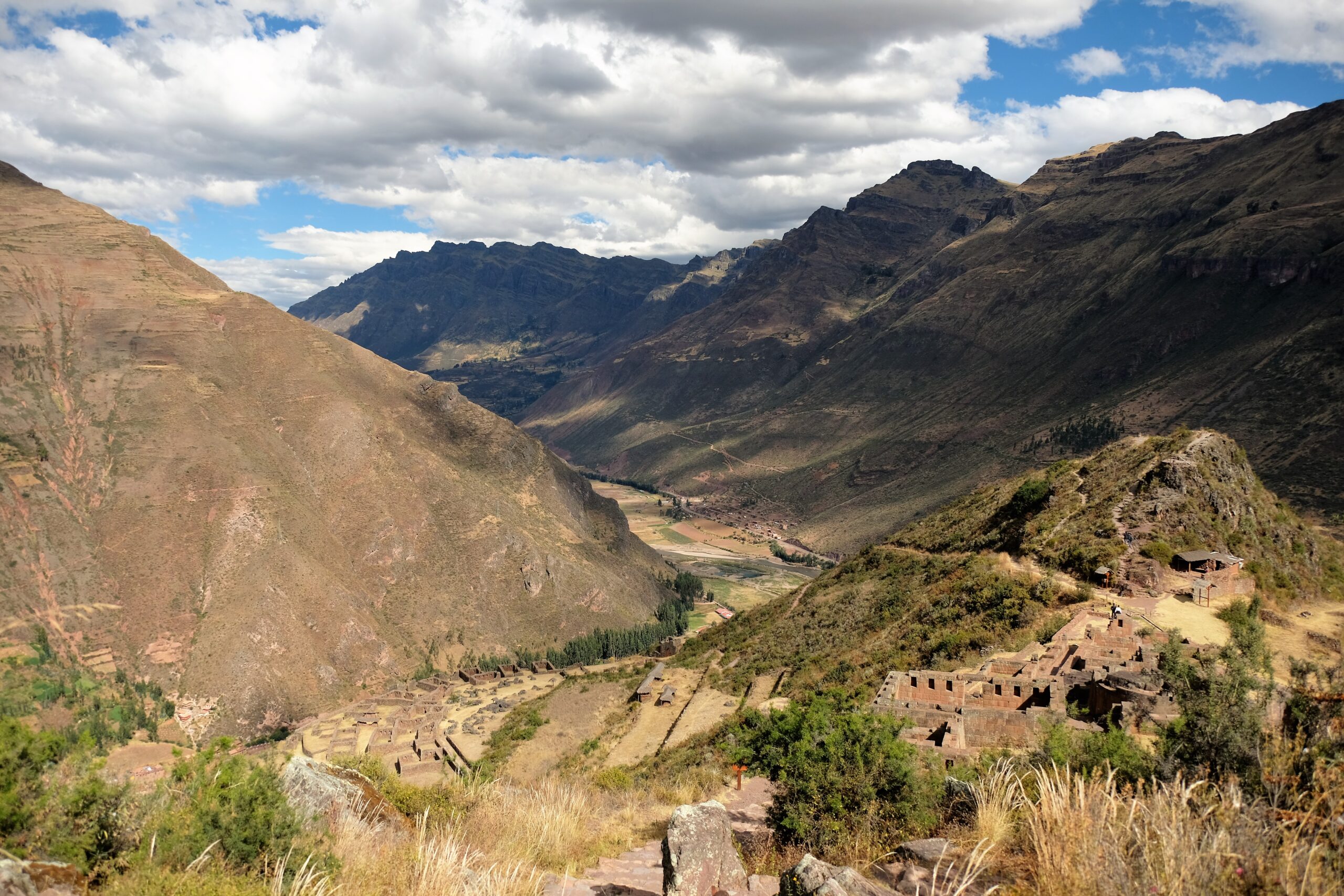
Pisac is around 33km from Cusco and takes anything from 45 minutes to 1.25 hours. It’s a lovely drive there, first heading up the mountains surrounding Cusco, then plateau, then the long windy round downhill to Urubamba Valley (a.k.a Sacred Valley of the Incas). As with my trip to Ollantaytambo / Chinchero and Moray I wish I had more time to stop on route to take in the vast, varied and striking landscape. There are so many lookout points and magnificent views along the way, I would have liked to take some time to appreciate them more. With only my memories to reminisce on, even those fleeting moments as we drove by still make me smile.
Two routes to the ruins
In my haste to get the day started I didn’t do any planning. My modus operandi: get to the location, ask around if destination isn’t obvious, then get walking. Ha! Who needs to plan…famous last words! I thought I’d skip the market till the end of the day, that was about my best decision of the day. I asked around where the entrance to the archaeological park was, then steamed ahead!
Now, there are two entrances to the Pisac Archaeological Park. First, is in the middle of the town near the market, the route I did (entrance jus to left of the church in the Plaza de Armas). Second, is a short taxi ride around 9-10 km on the other side of the mountain/hill. I have no regrets doing my route however, most of it is uphill. If you use the entrance at the back then most of the route is downhill, finishing where I began (town centre).
It’s not a difficult hike, I’d say my total distance was around 4km, definitely not more than 5km. The paths were in good condition and well marked out, though I’m not sure I would be keen hike it if it was wet. It was steep in many parks, with a total elevation of just over 500m; that includes some of my detours. Going back to my earlier statement about good decisions, that was sarcastic. In the very least I should have checked a map or how long the hike was. I only discovered the second entrance because I just kept on walking. In the back of my mind I kept thinking I would have to hike the same route back!
Pisac Archaeological Park
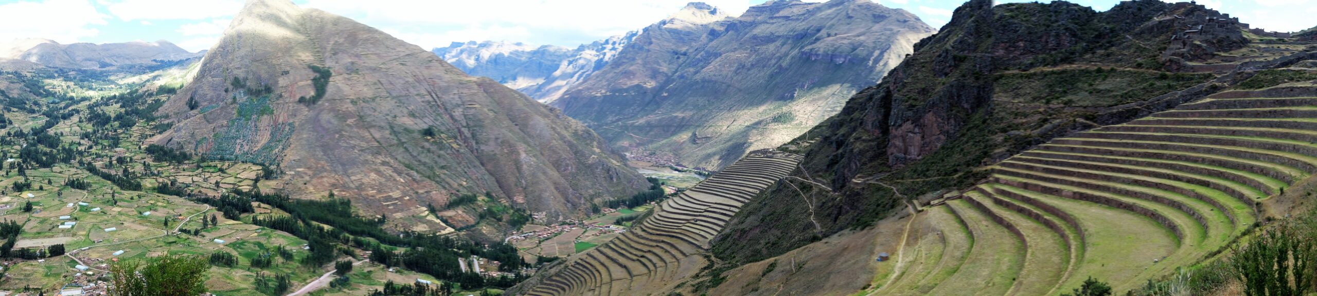
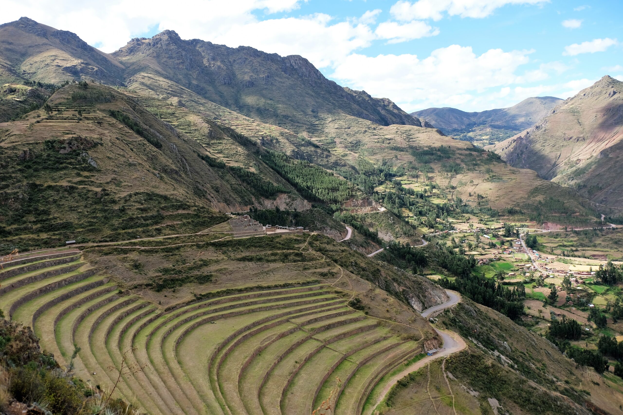
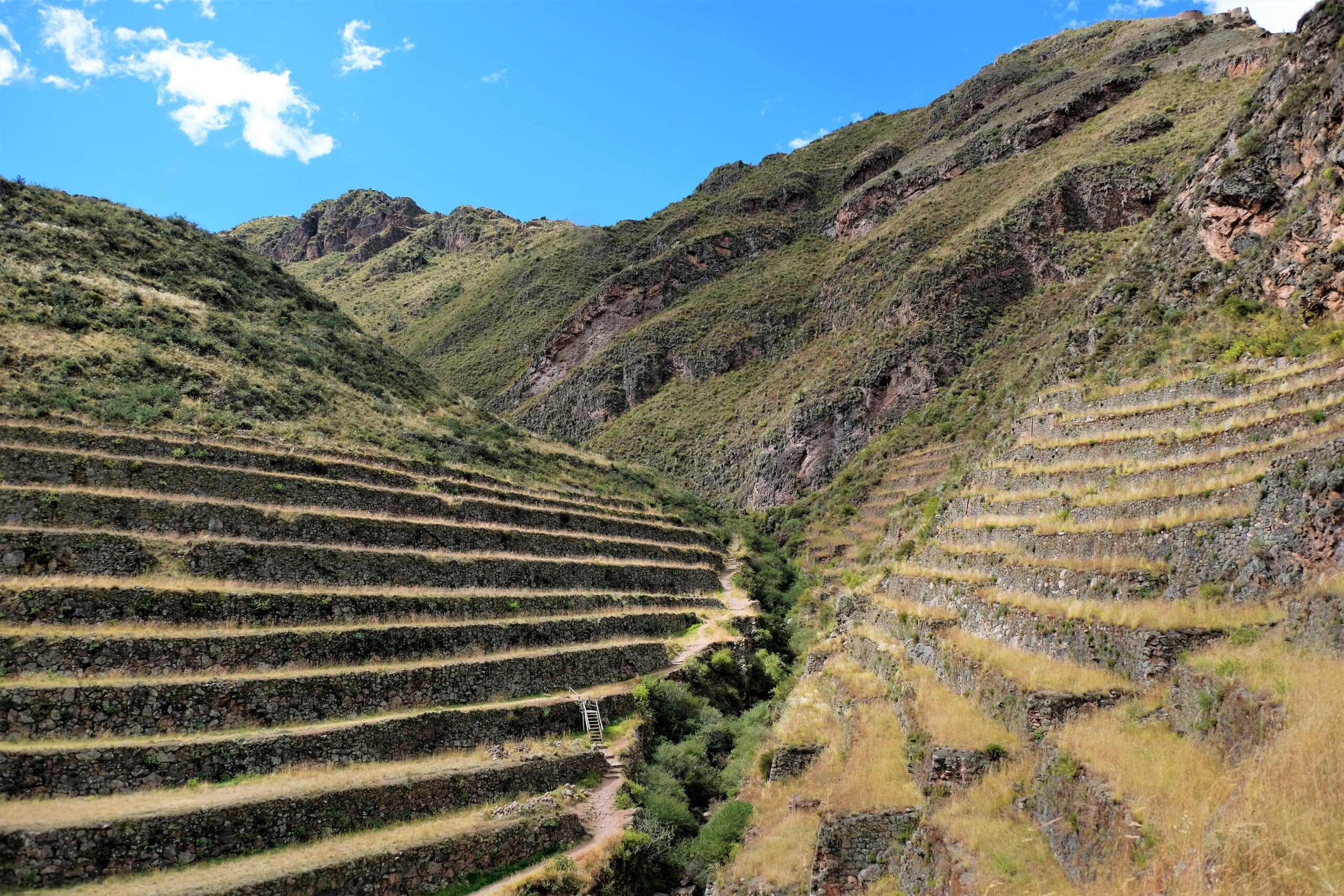
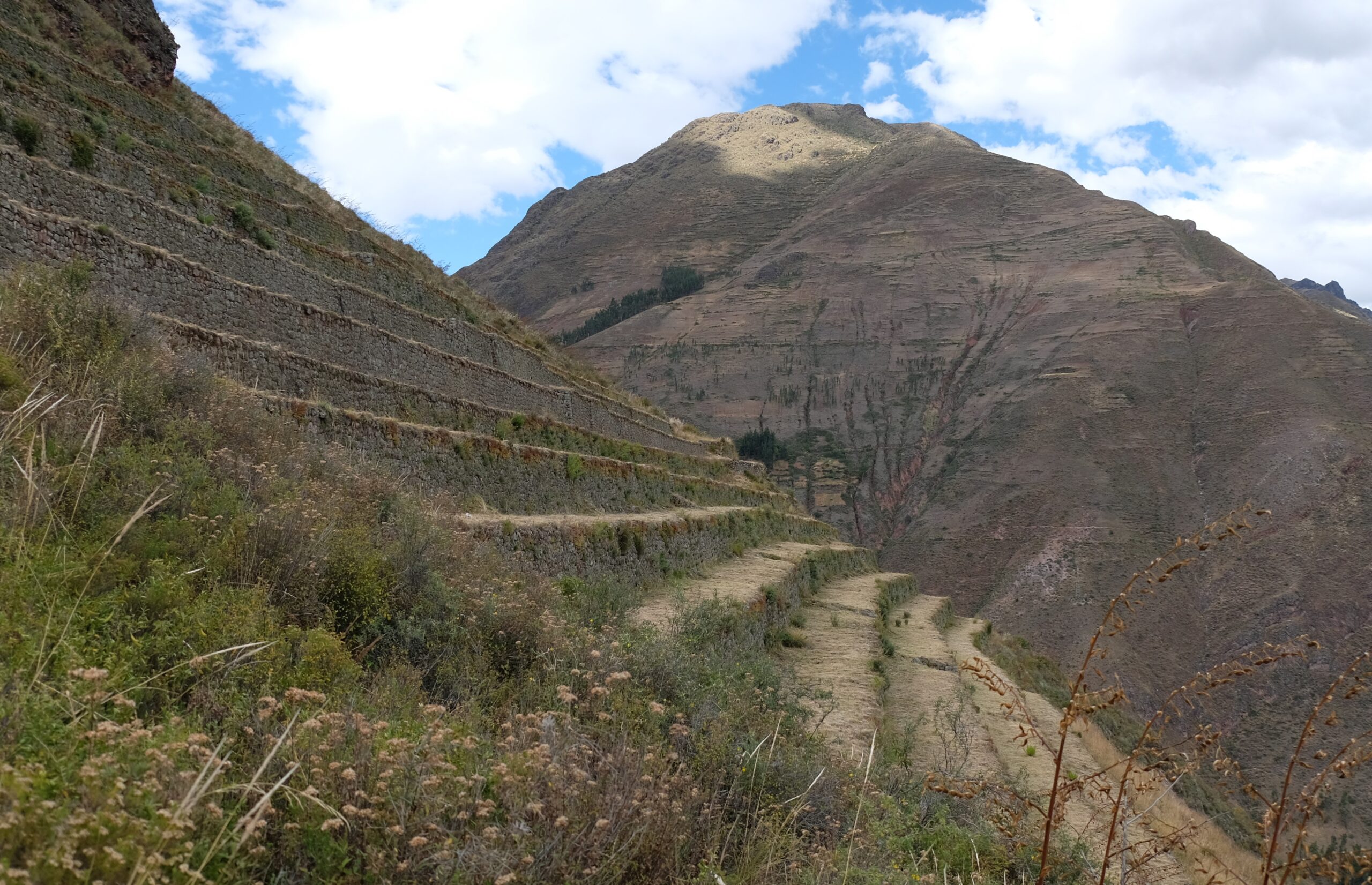
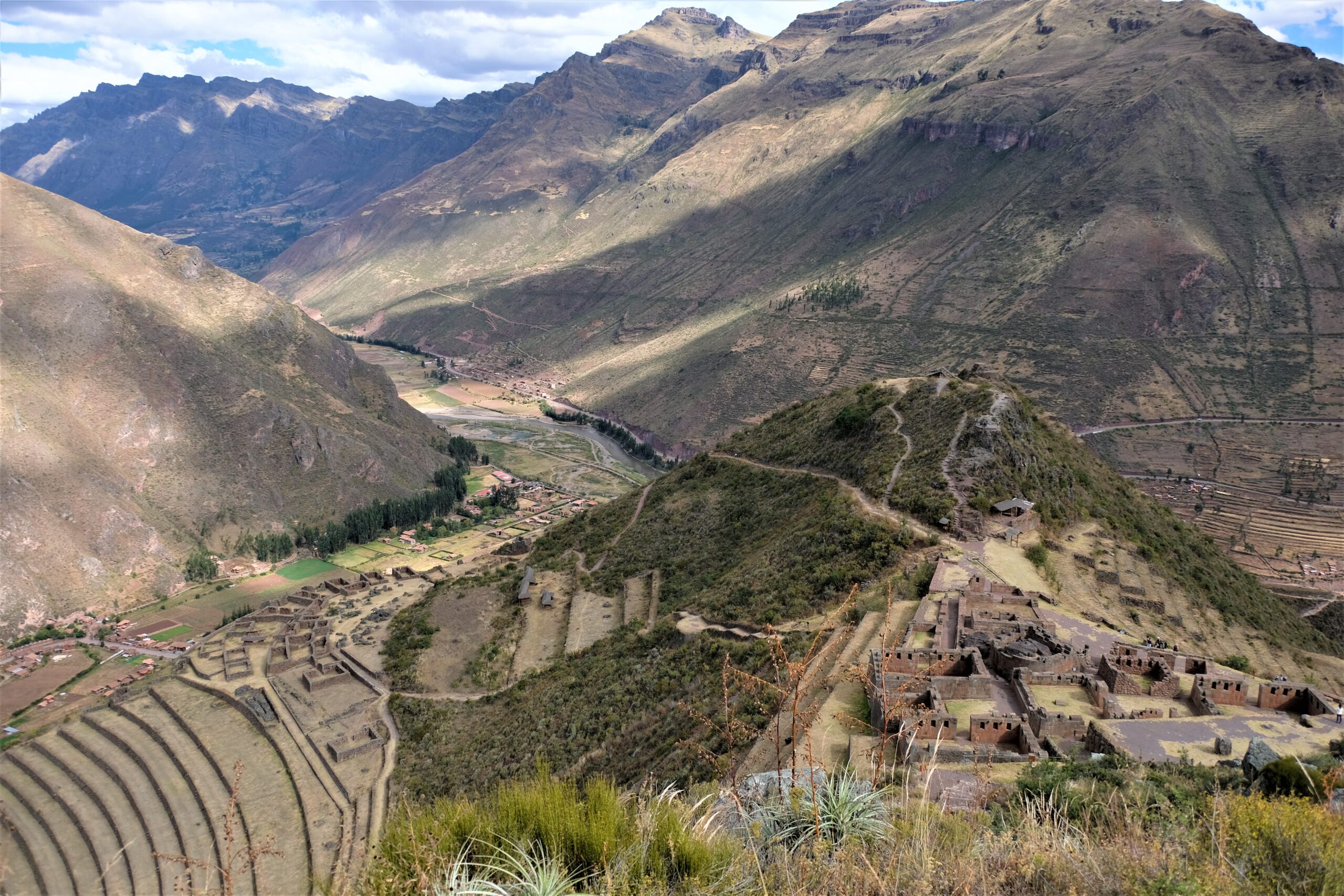
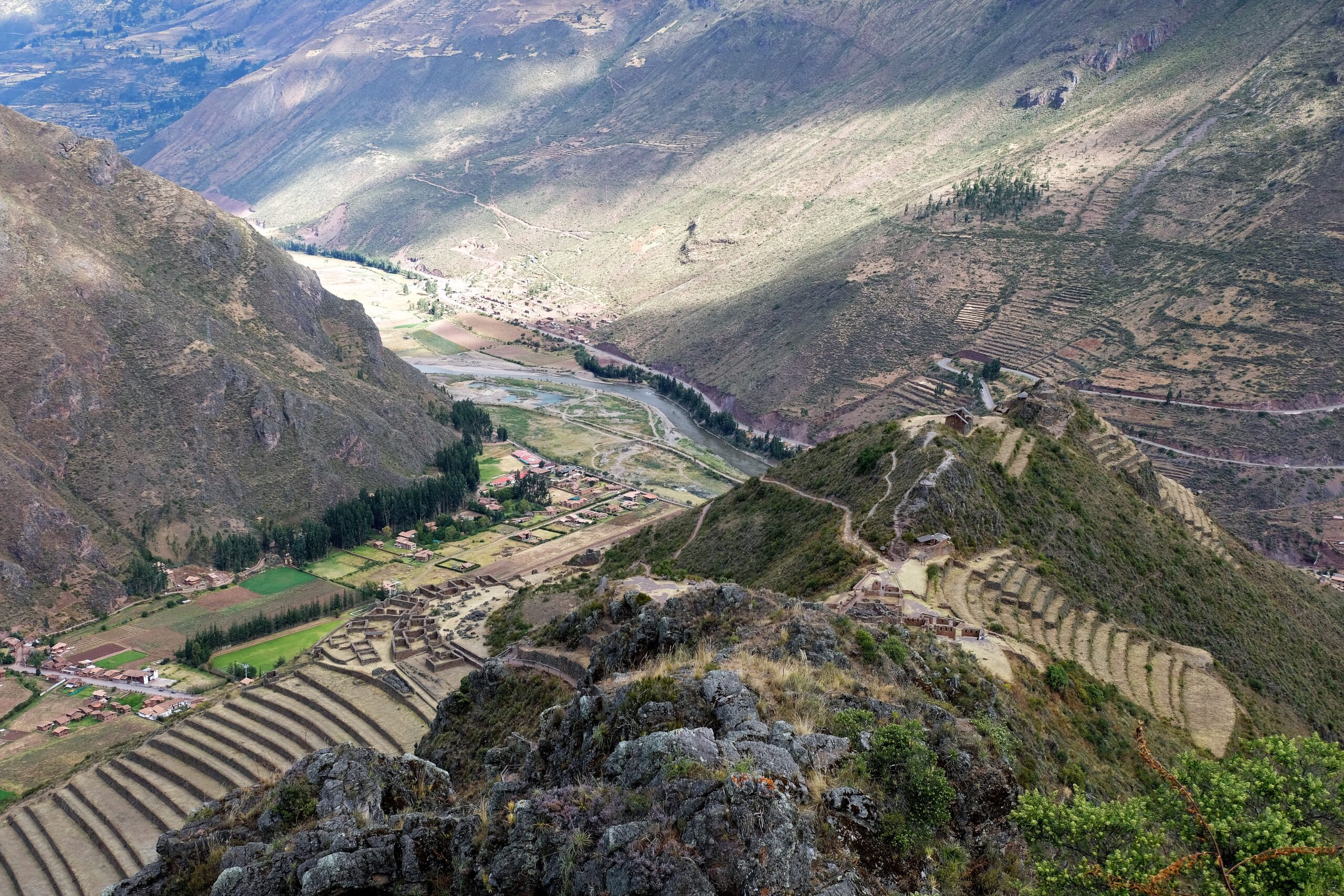
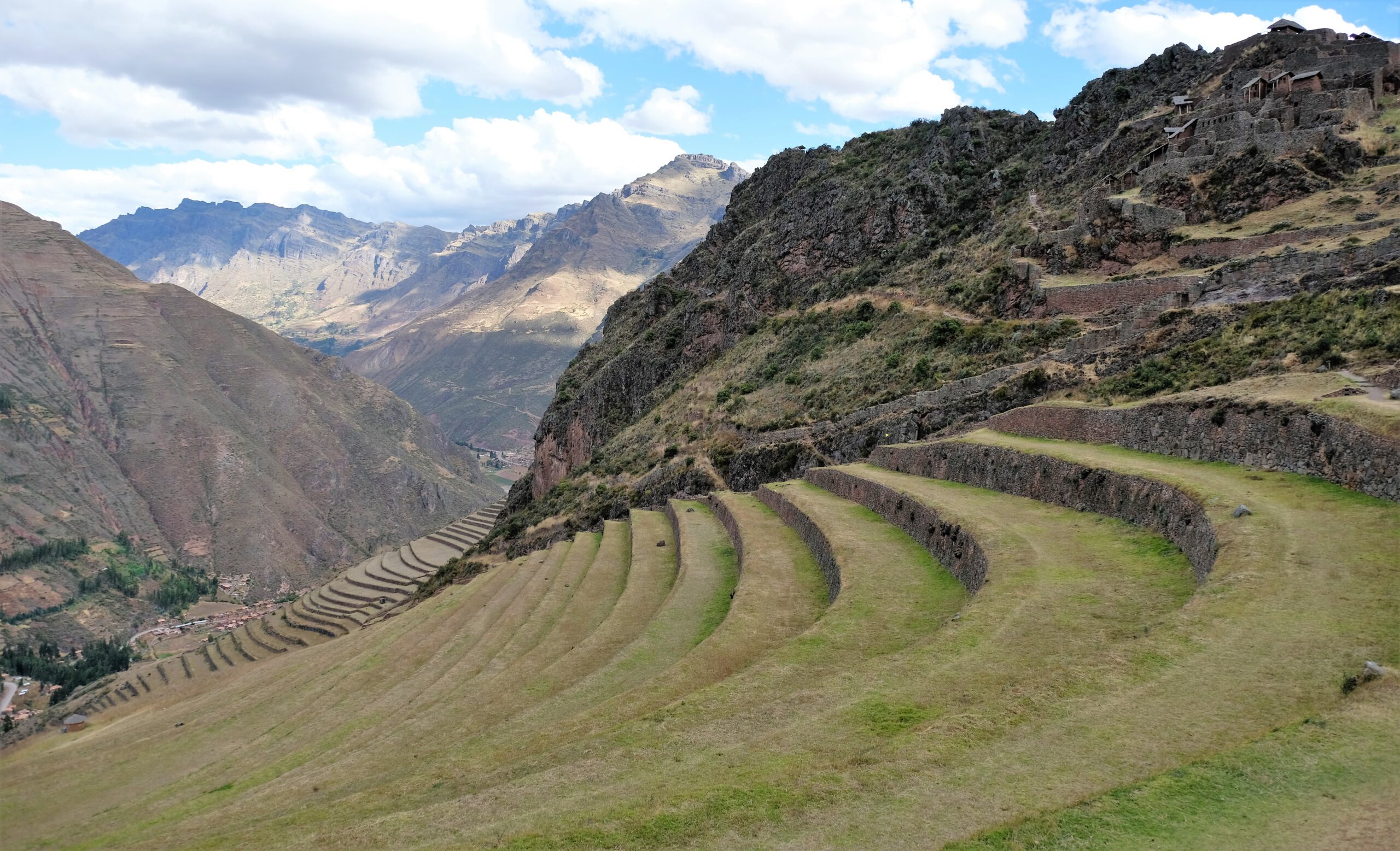
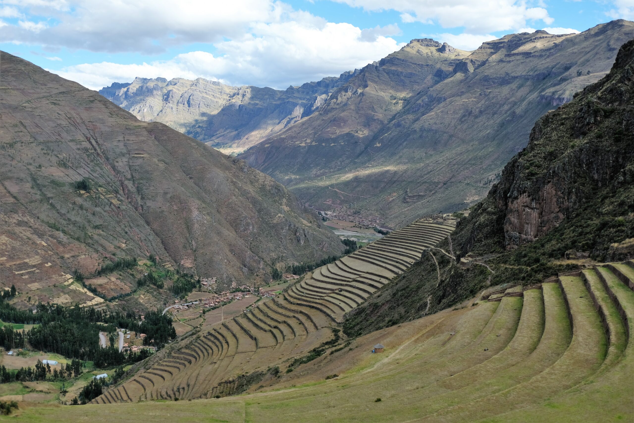
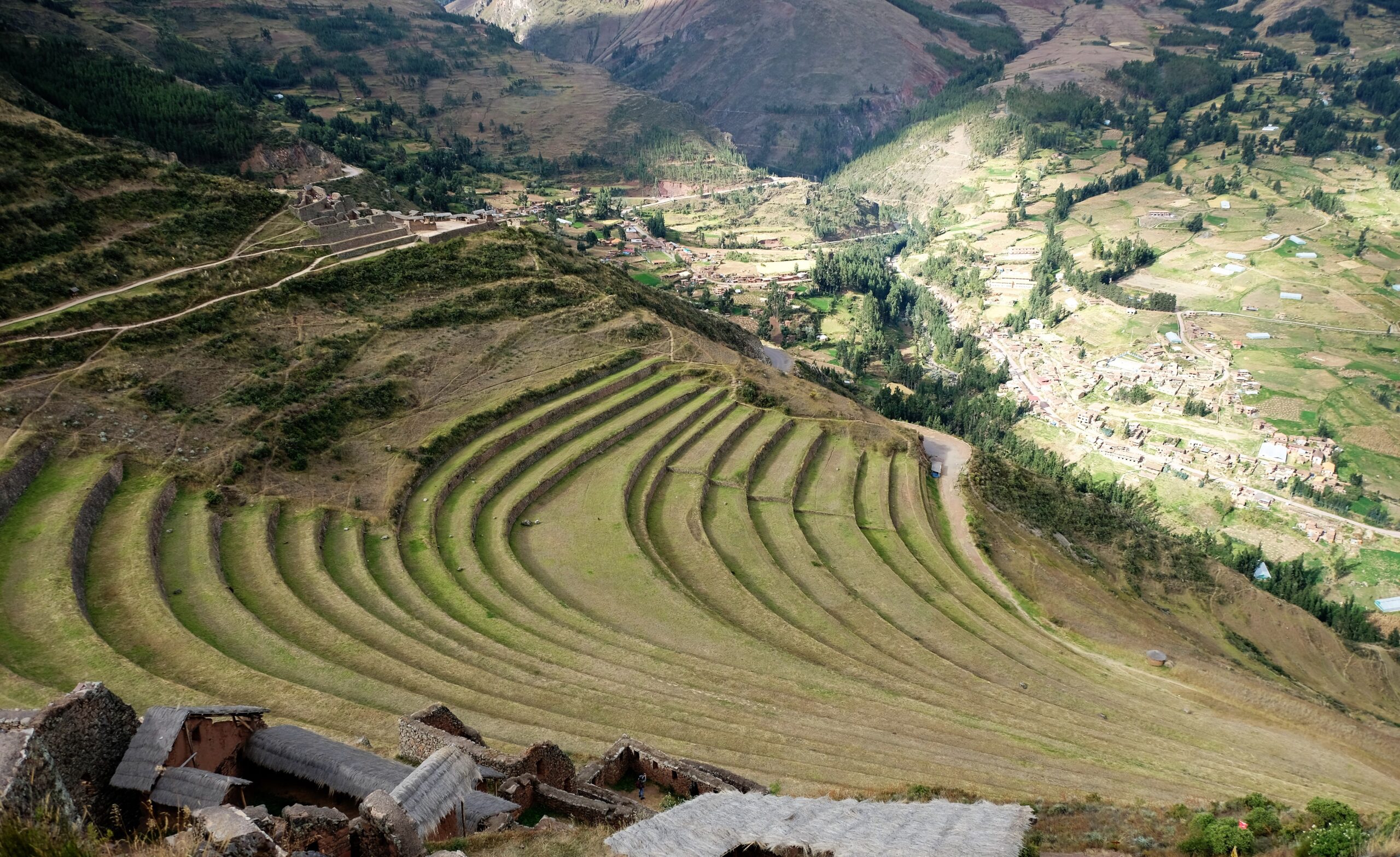
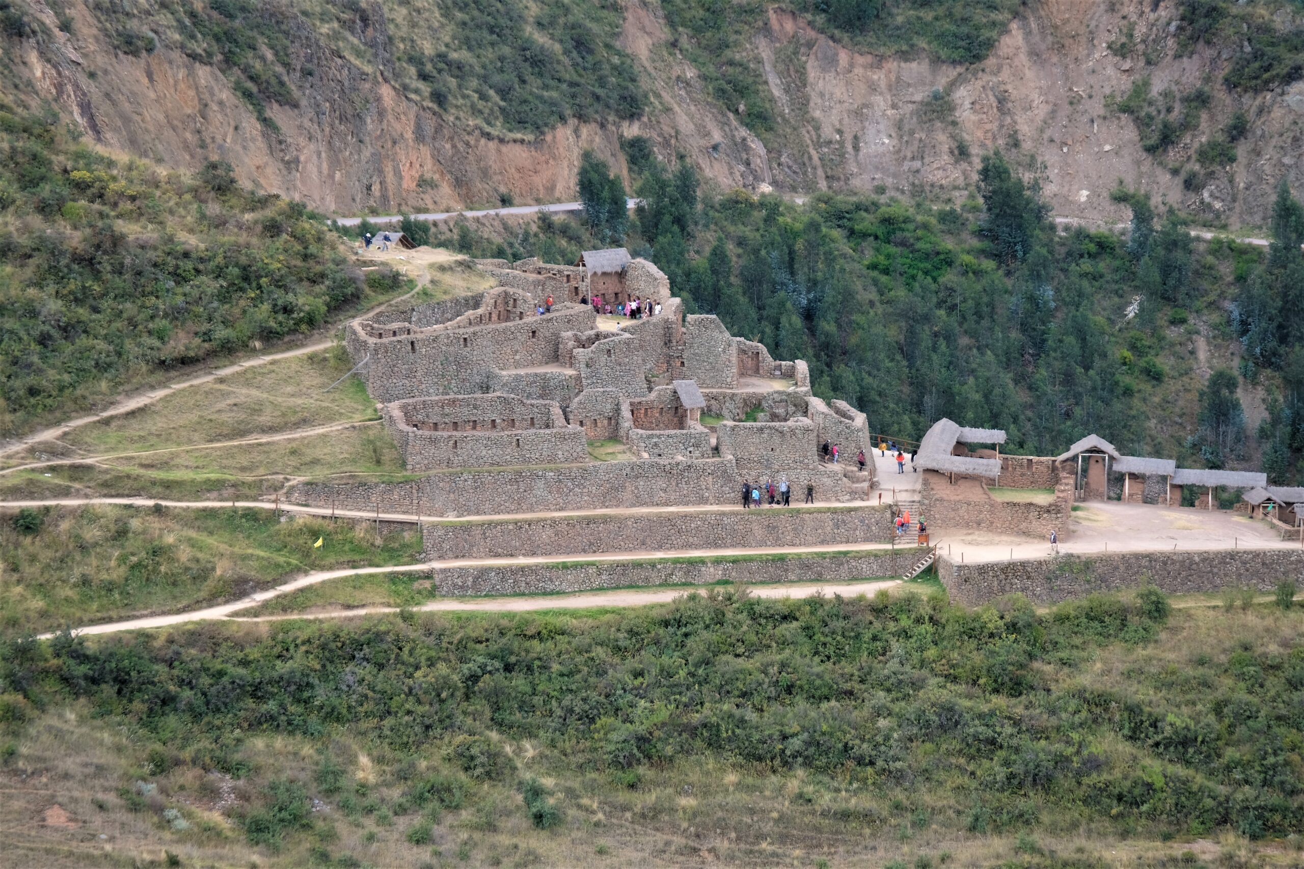
Nearly all Inca ruins have very little accurate information about them, Pisac is no different. The main route is around 3.5km, passing by terraces, agricultural buildings, houses, temples, military structures etc. The site is divided into sections P’isaqa, Inti Watana, Qalla Q’asa, and Kinchiraqay which I’ll get into later. Pisac is hands down the largest terraced area I had seen. This area would have produced massive amounts of food for the region, so in my humble opinion must have been a very important place.
FYI:
- Walking top to bottom is about 1.5-2hours, going up is about 3-3.5hours
- I’d highly recommend taking water with you. There are a few locals selling water and trinkets along the way, but I don’t know if they are always there.
- The weather can change quickly, I had cold to hot in less than 30 minutes, then cold again then hot again – worth putting suntan lotion on
- Elevation is around 500 – 550m, starting at 3000m above sea level. Not as high as the surrounding mountain of Cusco but you can still feel it.
History
Again, this is a bit sketchy. It was either built by Pachacuti to memorialise his victory over the Cuyos; plural for guinea pig and one of the names used for the local delicacy, roasted guinea pig. Or, it was built to protect Cusco from attacks from the Asháninka – known by the Incas as Anti or Campa (known to be formidable warriors). Personally, I don’t see why it could have been built to serve both purposes. There is no evidence of the region being occupied before the Incas so there is consensus that it was built around 1440. Yes, there are military structures throughout Pisac, but nothing like Ollantaytambo which is compactly built. Here with the sprawling terraces I can’t see its primary function being a military site.
What to see
This is where is starts becoming tricky. I did quite a lot of research, as always cross-referencing information and still some details about Pisac aren’t clear. Not for everything, some people call/label things differently. If you do a search on these contentious locations, it’s near impossible to confirm or deny. Like I said this is not for all the locations in the archaeological park. What surprised me is that I couldn’t even find an archaeological map listing everything. I only found two, neither great examples, nor are their labels the same…or even completed. Very frustrating! That being said, I’m going to try my best to label my pictures correctly. If you happen to know I’ve done so incorrectly, please do let me know! One more thing, I found so many sites that have cut and paste (verbatim) from each other so who knows what information is correct.
Terraces
The trail starts quite steep with large stairs and gets progressively steeper. It didn’t take long to get to the first set of terraces spread across two opposing hillsides. These are separated by the little Kitamayo creek/stream which starts somewhere up in the mountain from what must be a natural spring. Crossing the creek bridge, you can hear the faith trickle of water below yet hidden from sight by foliage. From here the route takes a steep incline for a short distance as it winds itself up the mountain to yet more terraces. I must include, I followed the more well-trodden path, though there were many others that I saw. It would have taken me 3 or 4 days to explore the many routes up and around the mountain – if I had time I would have come back to do so.
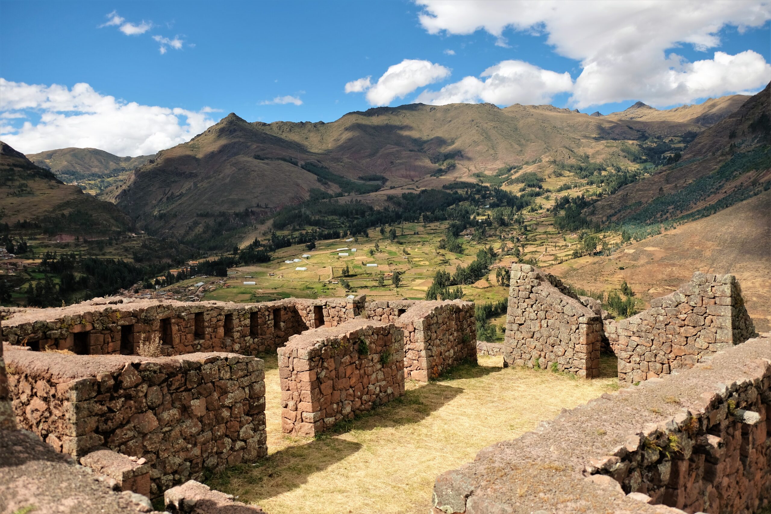
Store Houses
I don’t know what these versions are called as they are very different to those at Ollantaytambo which are called qollqa. These at Pisac are much smaller and rudimentary by comparison to the qollqa/qullqa in Ollantaytambo. In Pisac they are built of smaller stone then plastered with mud, their roofs a basic structure with thatching. The mud plastered helps these buildings blend into their surroundings and no doubt aids in insulation. Instead of larger rooms like the qollqa, here they are much smaller but there are many. If you compare the ration of terraces to storage rooms of Ollantaytambo and Pisac you would imagine Pisac to have more. But, unless many of the Pisac storage rooms are somewhere else or destroyed there doesn’t seem enough of them at Pisac.
I’ve seen these store houses, or at least a section of them being referred to as Kinchiraqay – I don’t know what the word means. Where the word has been used is for the first group of store house (qollqa) I saw. These are perch precariously on the side of the mountain at a very steep gradient. The route I took didn’t take me past them, however there are a few routes that you can take leading through this area.
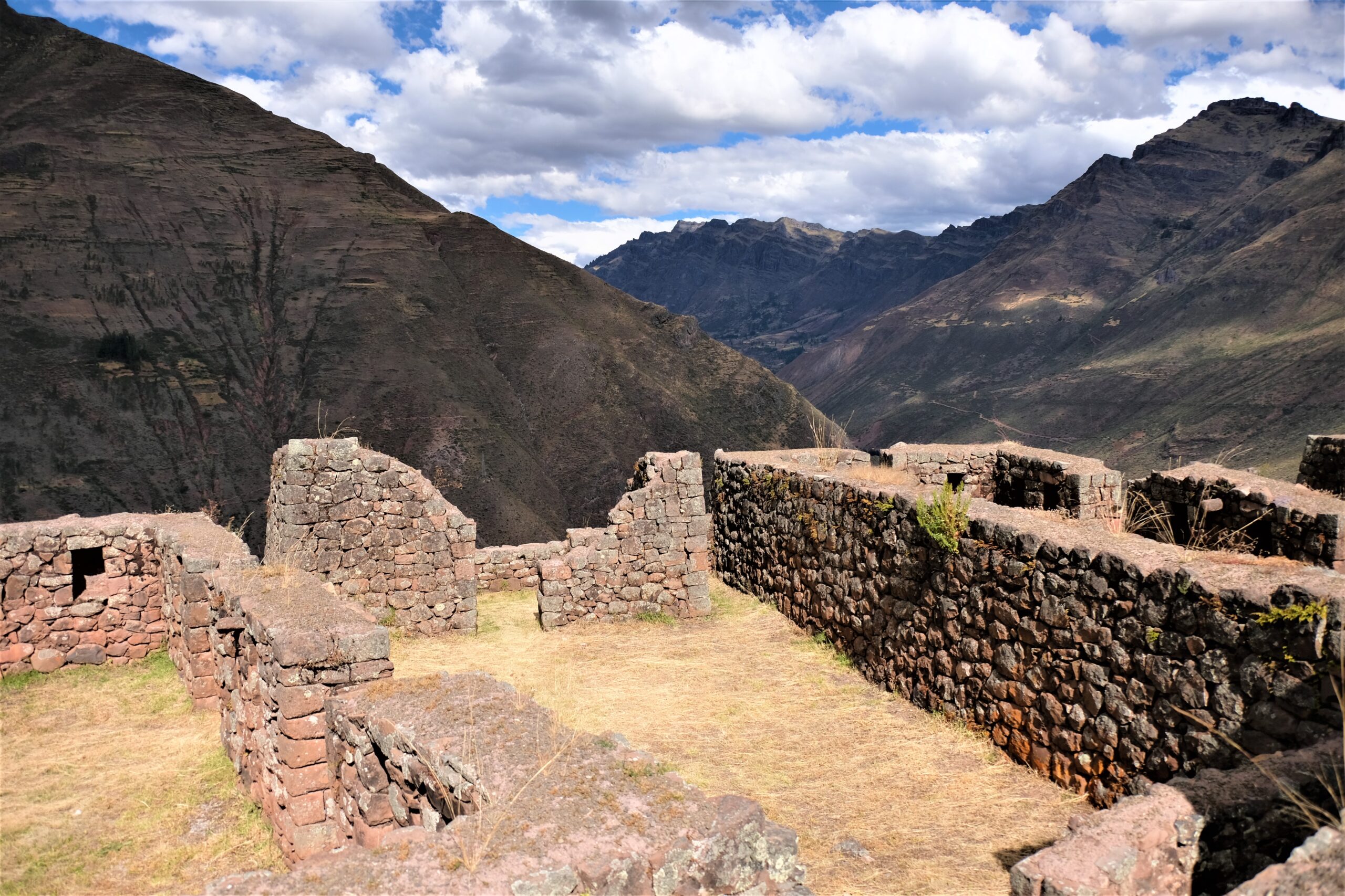
Pucaras / Towers
These are dotted through the mountainside. Some stand as solitary towers, others amongst structures like the storage houses or within the urban areas. All those that I saw had some vantage point of the valley below and were built well using larger stone. They seem to have two formats, one that is round and the other rectangular. Both have quite a few windows and with their stonework left natural without plaster. I spotted about 15 towers, no doubt there are/were many more. Some are in better shape than others and I read somewhere that many of them follow aqueduct systems. My route tended to follow the crest of the mountain, at each peak was another tower. Unfortunately I missed to aqueduct system, how I did this I don’t know. Retracing my route I’m almost certain I would have had to cross it as some stage (at least twice!), I must have missed it, pity!
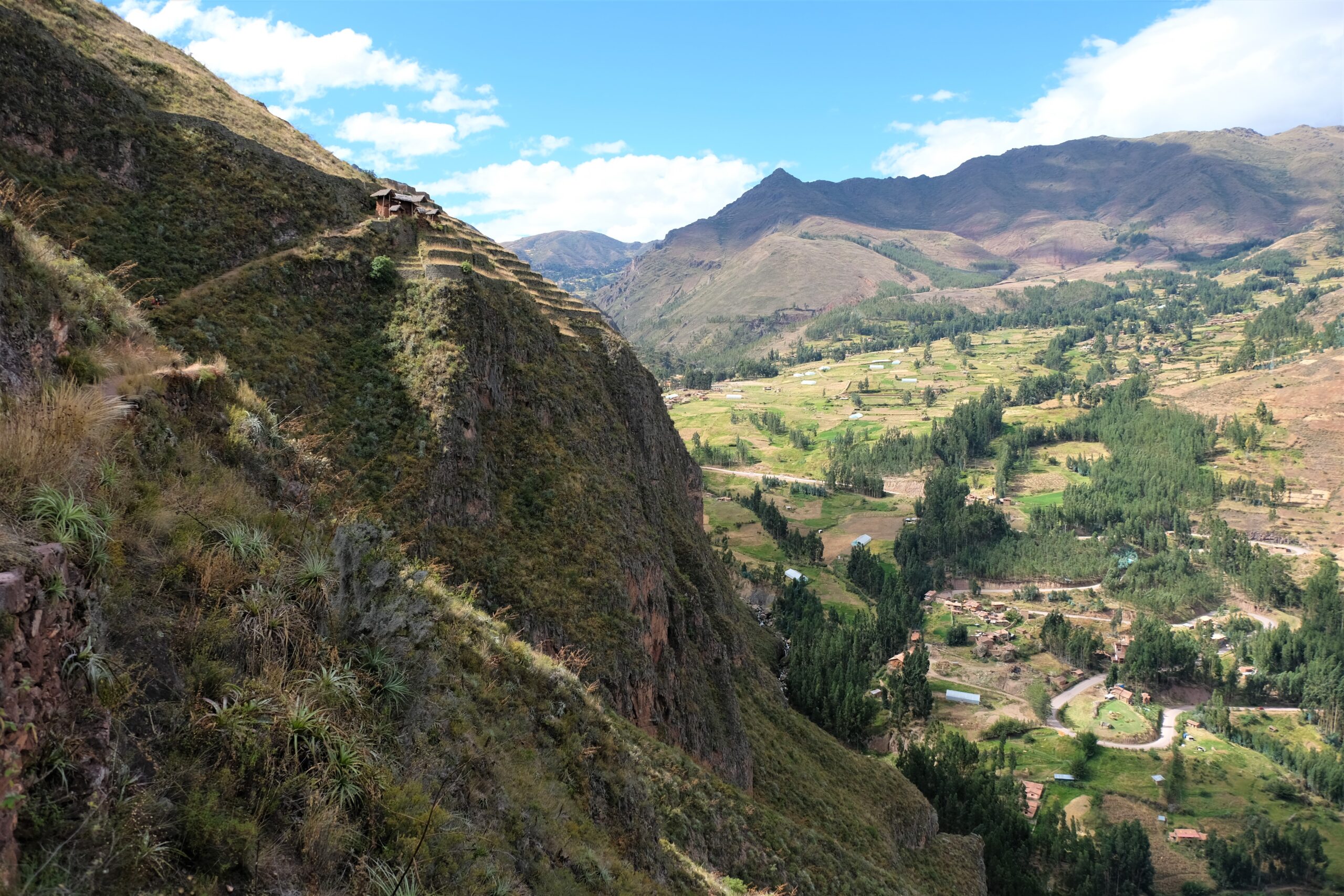
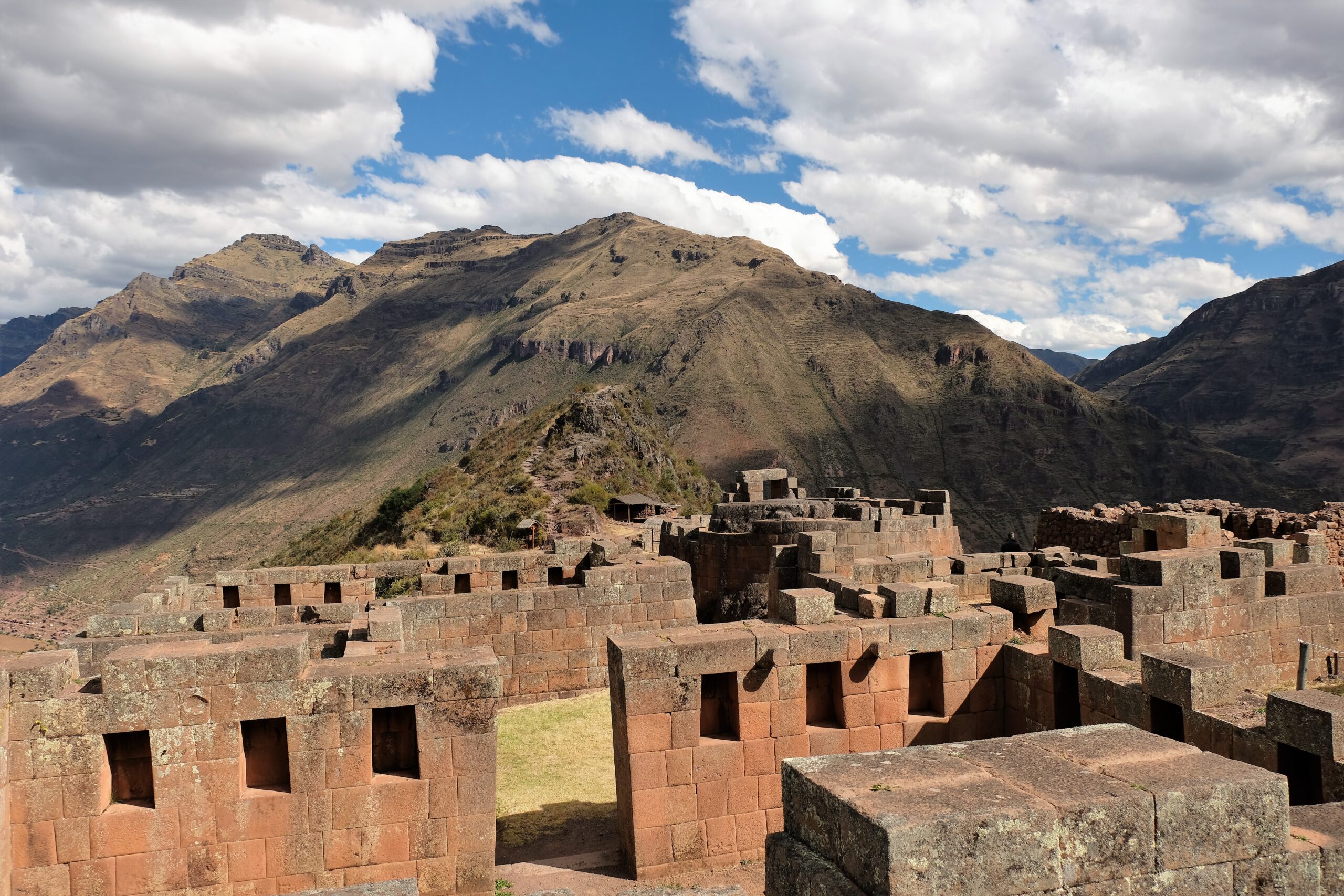
P’isaqa
This was the first residential/urban area I came across, about halfway up the mountain (maybe a little higher). Living here you get an awesome view of the Urubamba valley, Machu Kuntur Sankha (opposite mountain) and the smaller valley between the two mountains. Following the contours of the hillside, P’isaqa is laid out in a semi-circular footprint. This is best viewed as I tracked higher up the mountain. The structures are quite large, many have numerous niches inside which made me question if this was a “normal” residential area. My rationale for this is twofold: firstly, their size, the many niches and quality. Secondly, their location. Not for their view of the valley, no, it’s proximity to the temple complex a stone’s throw away. The temple complex is around 100m away behind it and a little higher up the mountain.
If following the format of many other Inca temple complexes; those living close to them were either high status individuals or people associated with the temple. Taking that thought or blueprint into consideration I don’t see why P’isaqa would be any different. I’m not professing some sort of epiphany, who knows maybe the archaeologists have already said P’isaqa is linked to the temple complex – I just couldn’t find any. I did find a few pdfs in Spanish about the archaeological park but could translate them. Taking that into consideration there may be a lot more information about Pisac than I am led to believe.
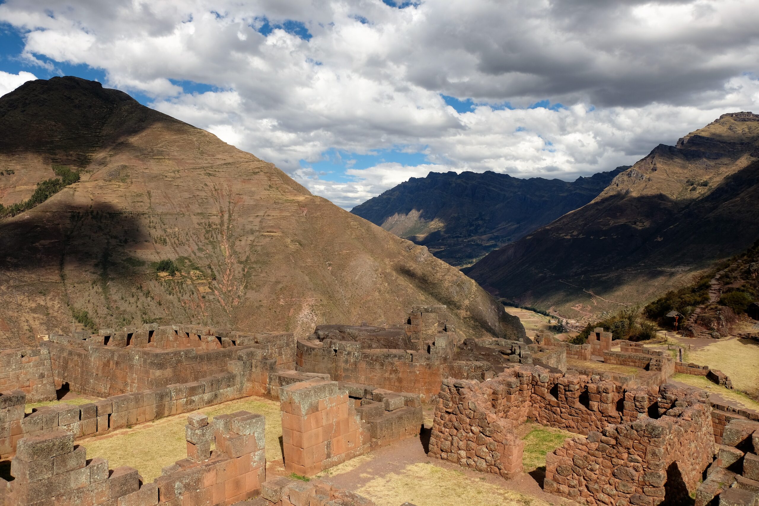
Temple Complex
For the life of me I don’t know why I didn’t spend more time exploring the temple complex. Well I do know. It was because of my lack of knowledge of the archaeological park (a.k.a planning). I didn’t know what else there was to see, nor how long the rest of my visit would take before I had to turnaround and head back to town. There was/is so much more to see that I did; more so paying attention to what I was seeing!
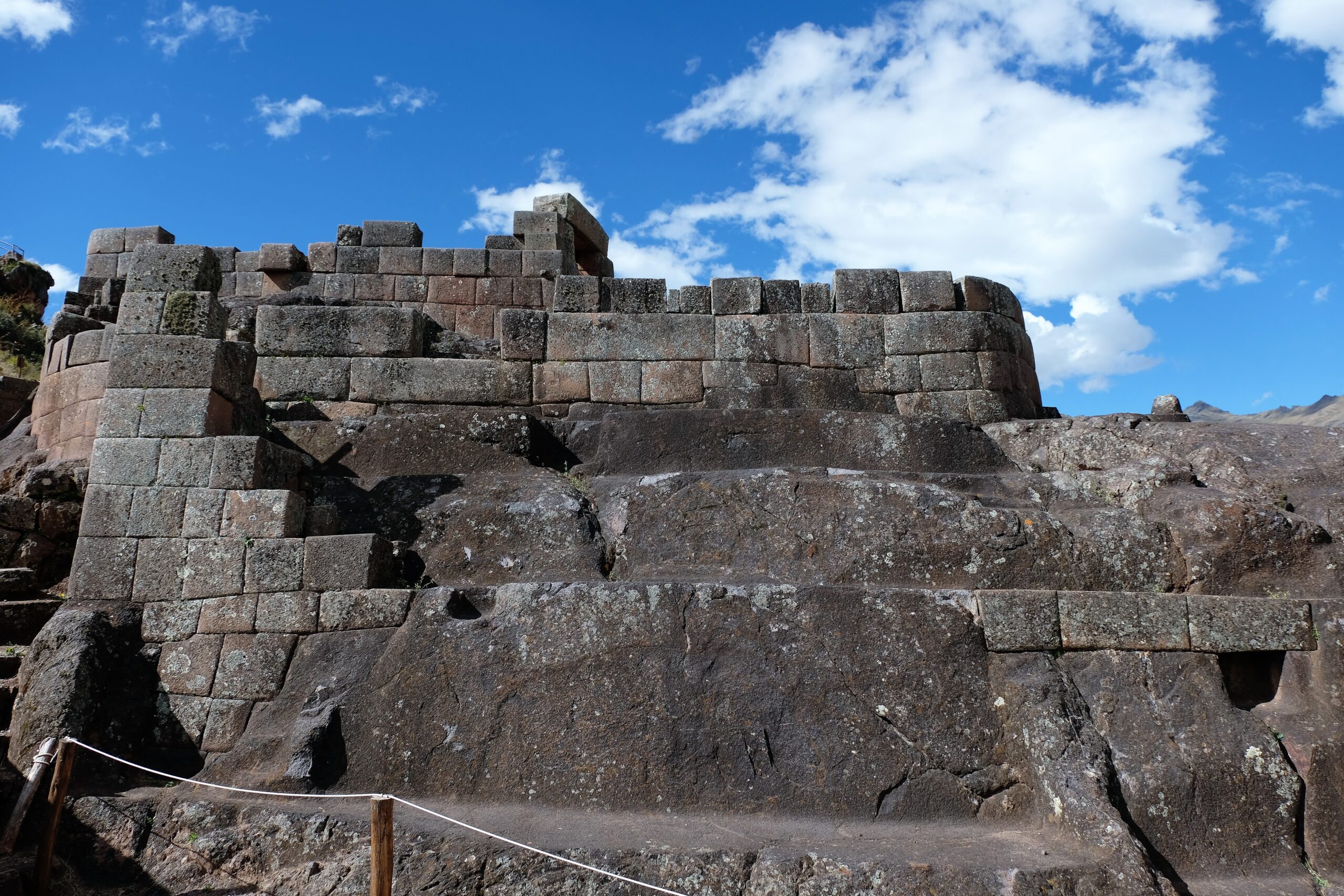
The vast majority of the buildings within this area are of the utmost quality. Exceptionally well-cut pink granite bricks with the smoothest surfaces. Unlike some other temple complexes, the stone used here have a uniformity. Whereas other temples (not all) the stones are different shapes and make to fit like a jigsaw. Here they look like they’ve been produced as part of a production line; they may be of different size but almost identical height. It’s possibly the most resembling Inca structure to modern brick building.
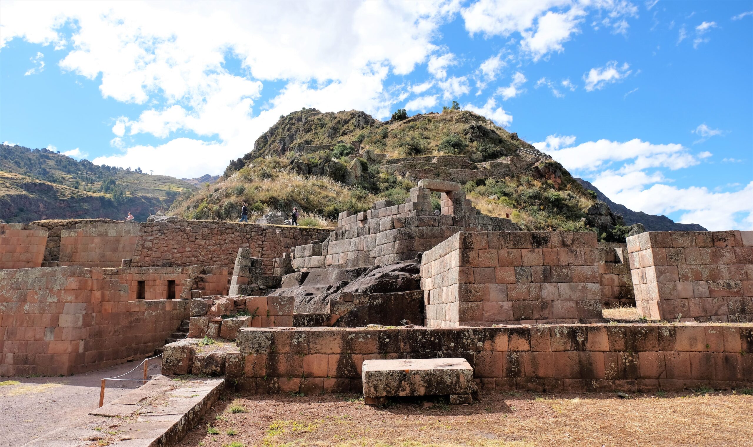
Temple of the Sun / Inti Watana
Special attention was paid to Inca temples/religious sites by the Spanish Conquistadors, Pisac is no different. I read that the temple complex incorporated a palace too, though I don’t know if this is true. Again, taking other sites into account it is very likely. Where most of the buildings in the temple complex are rectangular with square corners, the Temple of the Sun is distinguishable by its curved corners. That, along with its centre piece (which almost takes up the entire interior footprint); a large natural rock exposure which has been roughly rounded like an incomplete column. The top has been flattened with a small round stump protruding near the middle.
This little stump may seem insignificant, on the contrary it is possible one of the most important archaeological finds at Pisac. This rocky outcrop and stump is called a Inti Watana, roughly translates to “hitching post of the sun”. The exact function and use of Inti Wantan are not known, though there is strong certainty that it is linked to the Winter Solstice. Maybe reminiscent to a type of a sundial used to determine seasons. Considering Inti Raymi was the major festival of the Incas it is highly possible that the Inti Watana was used to calculate the Winter Solstice. More about Inti Raymi in my post on Sacsayhuaman. Such an insignificant piece of rock, yet there are very few examples left of these throughout all Inca ruins.
Tianayoc / Tianayuc
Heading further up the hill you find Tianayoc/ Tianayuc perched on the ridge. Some people call this a neighbourhood, though that doesn’t seem realistic to me; if you compare the other residential parts of Pisac. Like P’isaqa, it wouldn’t surprise me if it was related to the Temple Complex, maybe an administrative part of the complex (I have no rationale for this except for its proximity to the Temple Complex). Tianayoc/ Tianayuc in Quechua meaning something along the lines of “it has seat” or “that has a seat”; this comes from a rock cut into what looks like seat with armrests. I missed this, hence no picture!
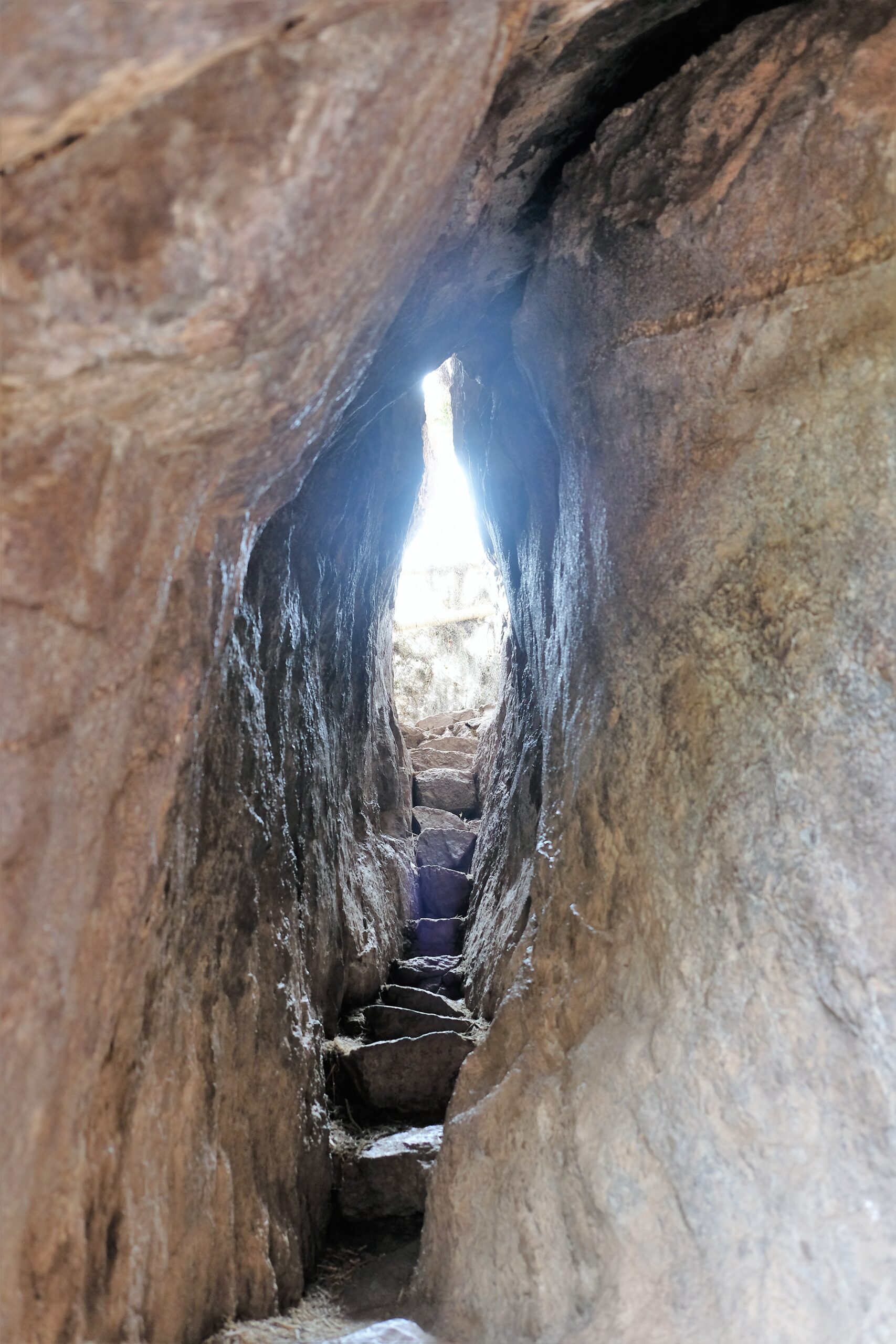
Chinkana / Chincana
I’m using the term “chinkana” in the same manner as I did when visiting Chinchero not like Sacsayhuaman. Here it is a short tunnel cut into through the rock heading further up the crest of the mountain from Tianayoc. Coincidentally it is the same shape as the two I saw in Chinchero, a narrow oval shape. This one was quite narrow in parts, I had to take my bag off my back and walk sideways. To me these “tunnels” must have some meaning. The Incas were master stonemasons and builders, so building around these rocks would have been child’s play…dare I say, easier.
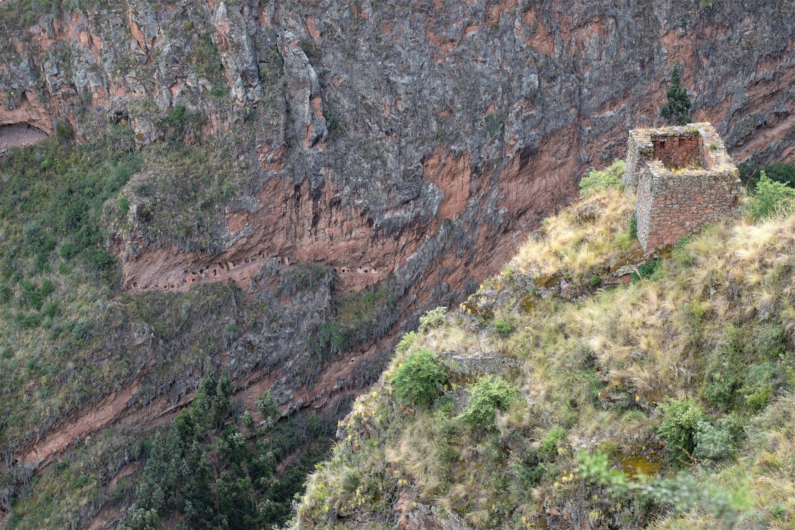
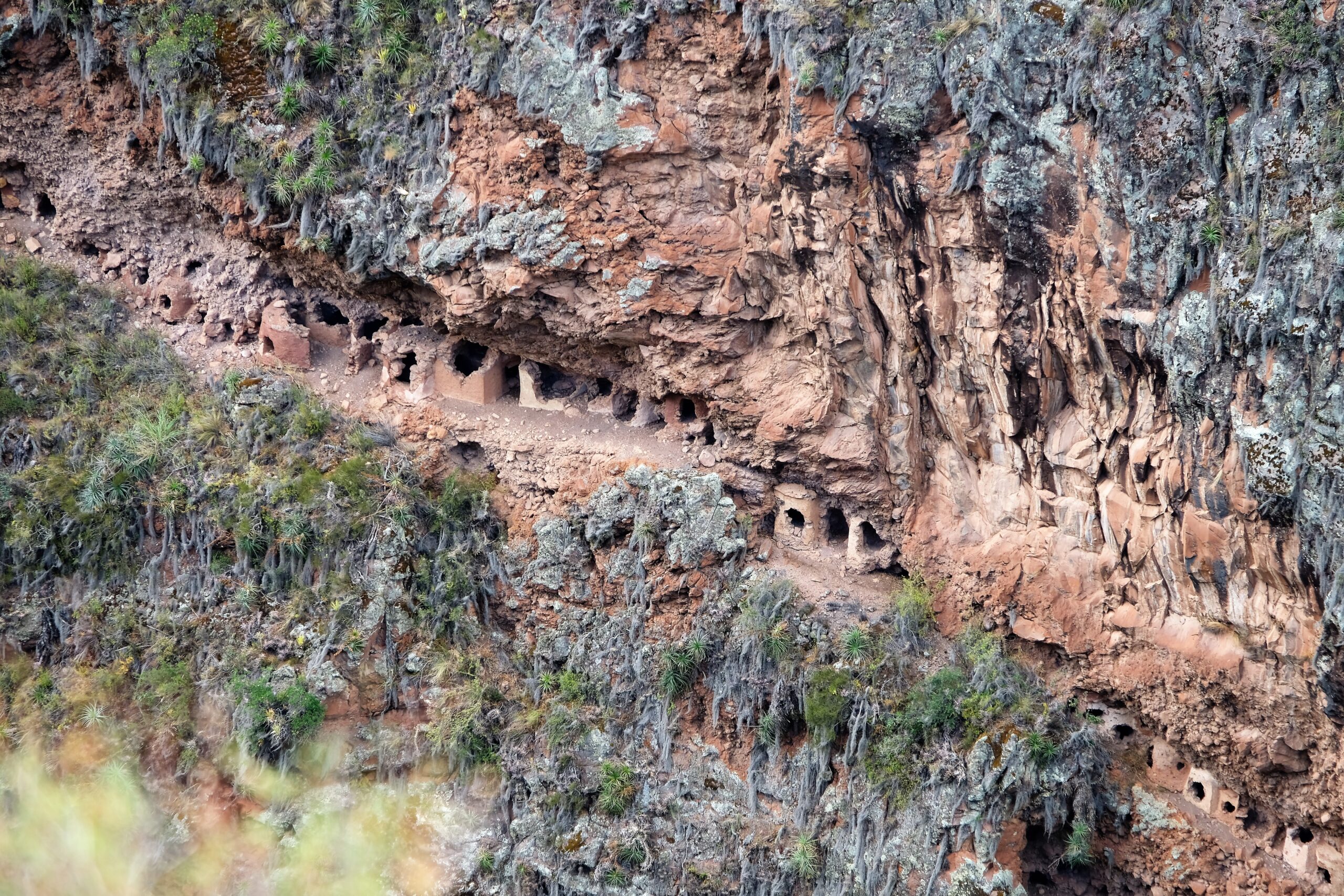
Cemetery
I had no idea this was a cemetery when I saw them, only finding out when reading up about Pisac to write this piece. When I visited Pisac I thought these structures could be linked to food storage, how wrong was I! These are tombs, and there are nearly 3500 of them. Made with a mixture of stone and mud plaster their location is befuddling. They’re not just fitted into crevasse or natural indentations into the gorge face. If you look carefully, you’ll see retaining walls have been built. Just to get to these tombs (I didn’t see any paths) would have been a challenge, building there is extraordinary!
There are lots of beautiful views and sites throughout Pisac’s archaeological park, but the cemetery to me was by far the most interesting – even before I knew it was a cemetery. They are strewn along the gorge; some is unfathomable locations. Sure, the area must have looked different during Pisac’s prime, but a cliff face is still a cliff face!
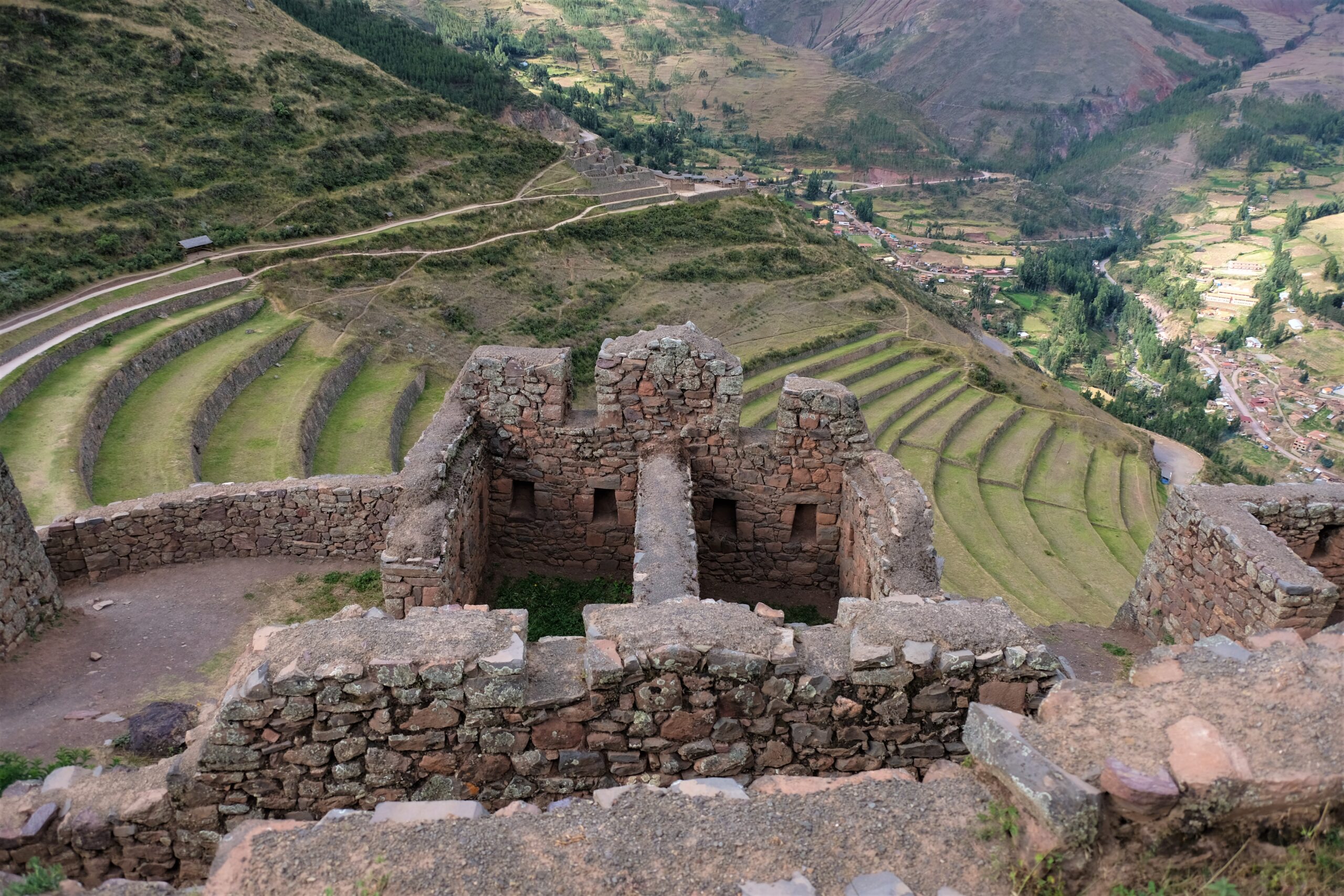
Qalla Q’asa
This is by far the largest residential area in the archaeological park. With views of sprawling terraces below and the valley ahead, this is a stunning location. Because of the route I took I missed the Amaru Punku (didn’t even know it existed before my research! GRRRRR!). Punku in Quechua means portal, Amaru means snake. This gateway is often referred to as the Serpent Door or Gate of the Serpent.
Back to Qalla Q’asa. In a prime position spread across the side of the hill like a castle overlooking its land. The buildings are here too having many niches inside of the thick walls making it look more like a fortress than residential dwellings – that’s not me insinuating it is a fortress. It is built on the slop of the hillside, just as the Incas terraced the land to farm, here they have terraced the land to build dwellings. The retaining walls giving the area a stern look like a castle build on a mountain top. This elevated position gives the impression Qalla Q’asa is the guardian of the land below, including that of Qanchis Raqay (the next residential complex on the opposite side of the terraces).
Citadel
This is the biggest building complex in the archaeological park, though it looks smaller because of the layout and position on the mountain. These structures are in reasonably good condition but a far cry from their heyday – Qalla Q’asa is often referred to as the citadel. It’s hard to imagine living here, it feels isolated and though very green. Even if the area only sustained a few hundred residence what you cannot see is their day to day lives. By this I mean the interesting archaeology such as water management systems like baths and fountains is difficult to see (most have been destroyed). To sustain such a population requires great planning, skill and execution.
There are some fountains and baths in the Temple Complex, but these would doubtfully sustain the population living in Pisac. What is left to see today is the shell of a complex and sophisticated community. Yes there are aqueducts, even so, just to irrigate Pisac’s terraces would require immense effort and resources.
Qanchis Raqay
This was the last of the sites in my visit. If you take a taxi to start with like I mentioned at the beginning of this blog, then this would be the first. Honestly, I didn’t spend much time walking through this area (full of tourists), though I should have given it a bit more time and respect. Here you get one of the best panoramic views of Pisac’s terraces. They are huge and cover a such a large area any farmer of today would be impressed at the scale of this operation. Add the terrain and altitude into the equation and this becomes a feat of mans willpower and engineering to overcome the greatest of odds.
My thoughts on these Inca ruins
Thinking back now, I know why I didn’t spend much time at Qanchis Raqay…I was tired! Just like visiting an art gallery, you get overstimulated and don’t appreciate the simple things. I would love to go back to Pisac, it’s deserving of multiple visits. I read that only around 35% or the area has been excavated, that doesn’t surprise in the slightest. What I am disappointed about is the lack of consistent and accurate information regarding the archaeological site. You can find quite a bit of information however it is mostly regurgitated (mostly cut and paste) Wikipedia information – which isn’t a lot if you take a look. Pisac is deserving of more time and attention. It will always play second fiddle to Machu Picchu but that doesn’t mean it isn’t important or spectacular…the Lourve isn’t only about the Mona Lisa!
Pisac
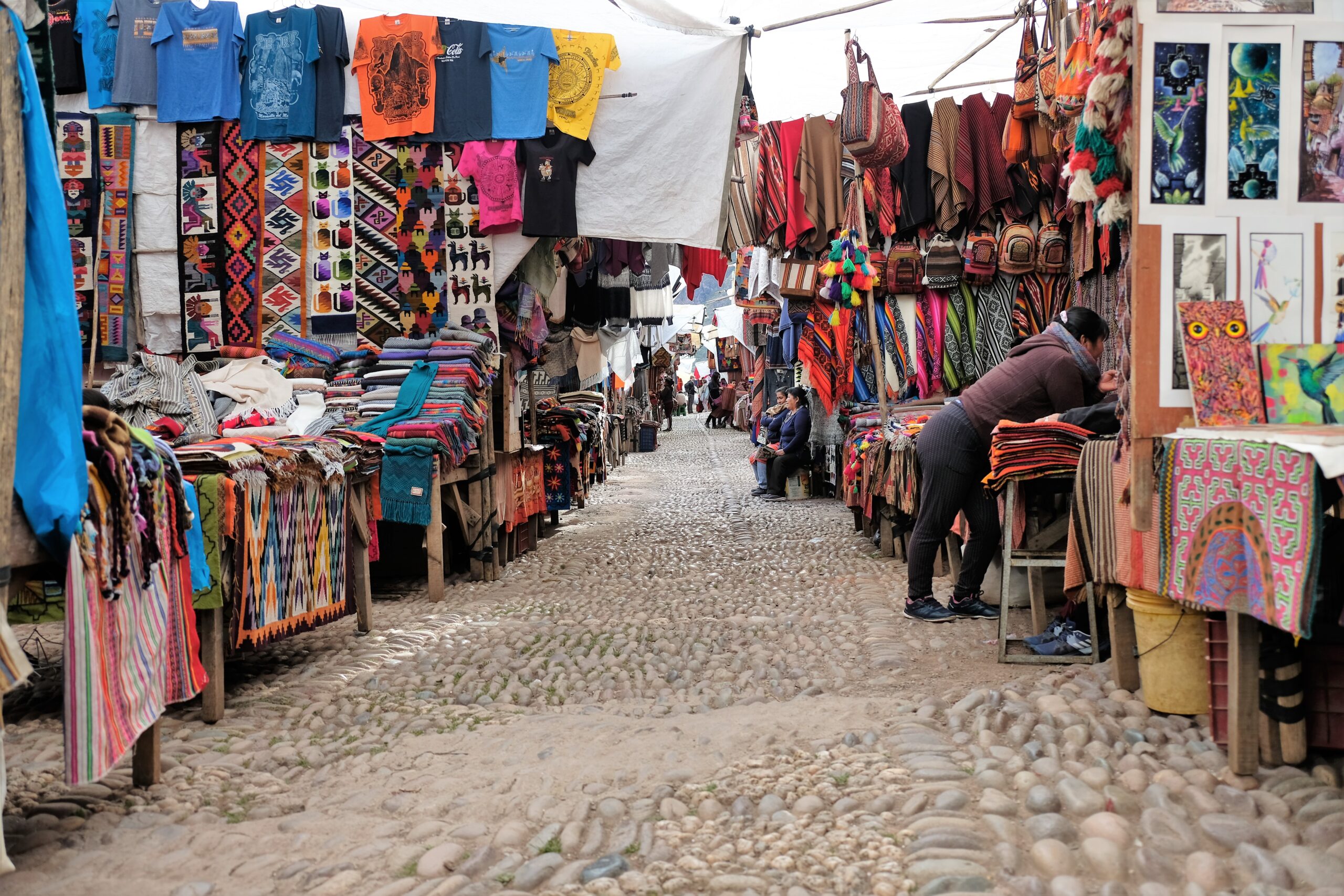
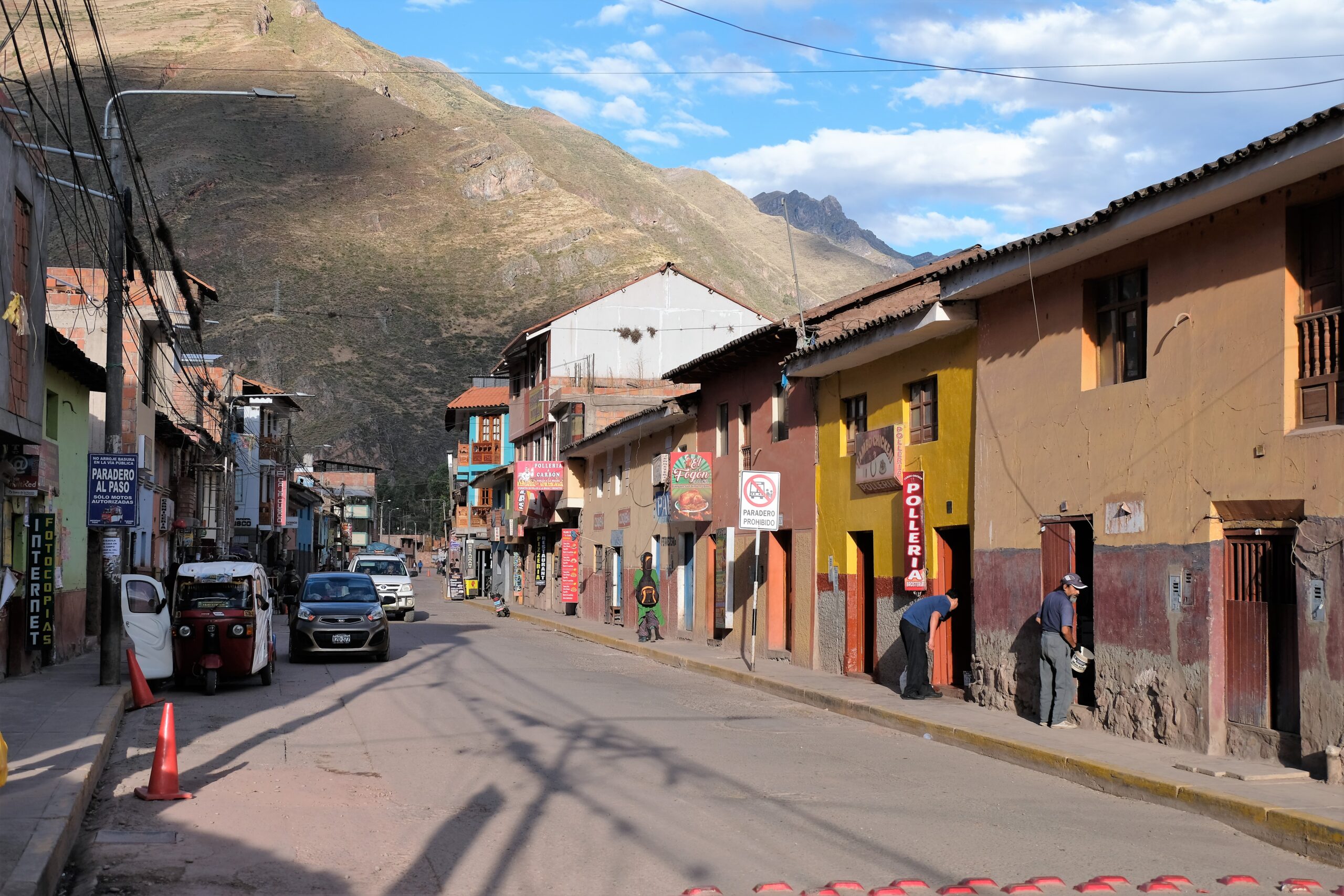
My visit had come to an end. Some firm haggling with a few taxi drivers and I shared a taxi back into town with a mother and daughter. I ambled through the Pisac market; a quiet day I was told compared to the weekend. Pisac’s market comes highly recommended (on Saturdays or Sunday’s I can’t remember), more authentic and much cheaper than those in Cusco – it is still very much for tourists though.
Considering the town has an amazing Inca archaeological park within the town, it has to compete with some more illustrious neighbours along the Inca Trail such as Ollantaytambo and Machu Picchu. If the town (or government) spent a little more time making the site more accessible with relevant information Pisac Town could benefit greatly! Unfortunately this can be said about every Inca ruin location except Machu Picchu.
I asked around town for the colectivo to Cusco, picking one up about a 100m from the town square. The ride back, first winding up the mountain gives stunning views of the Urubamba Valley. This route is likely the same, or at least similar, to that taken by the Incas over hundreds of years. It is a beautiful region of the country but for now I had a full and fulfilling day. My legs were tired after a few days of altitude spent on a stairmaster!
As per my usual, I will include more photos of Pisac than I done so here on my Batnomad Facebook 2 days after posting.